Sunday 10th October dawned overcast but clear. The visibility was going to be the dominant feature. After breakfast, I left Kildonan at about 10.30, I really should not be keeping my host from her work by yakking so much lol. My progress up Eigg's main road keeps being impeded by ripe blackberries. Which obviously, I have to go and pick. Anyway, the piece de resistance of the road north through the island comes when you descend Bealach Clithe [pronounced Byalach Cleey] and first the towering mountains on the neighbouring island of Rum (seriously, the place is called that) hove into view. At 2,800 feet, they are impressive at 4.5 miles distance. The next corner reveals the green swathe of Cleadale, the crofting community, over which the 1,000 foot high cliffs of Beinn Bhuidhe [Ben Vooy] tower to the east. I slowly ambled down the road, past the houses of Cuagach, the terrible sideroad to Laig Farm and the old folks houses. Then you arrive at a T-junction, at which I went left, towards Seaview. This house was occupied by Angus MacKinnon, one of the island's elders until his death, a few years ago. It appears to be empty now. The blackberries distracted me. You can walk to Camus Sgiotaig, the Beach of Singing Sands from Seaview, but don't fall off the cliffs. You've got a bit of a job finding the way down. Don't chase the sheep over the cliffs either. Please. Once on the beach, the white sands, if dry, produce a shrill shriek if you rub your shoes over it. Or just walk over it. The streams cut a deep channel right through the sands, and you've got to be careful not to fall through the layer of sands if the water has undercut it. Otters have been seen playing in the kelp on the tideline. Towards the south, there are caves and natural arches to explore. It should be possible to walk back to Laig Beach, a mile to the south, but do watch the tides. I climbed up the hill at the north end of Camus Sgiotaig and ploughed through some dead bracken towards the pass of Bealach Thuilm. If you want to you can cross the stile and descend into Talm, which is overlooked by an 1,100 foot high cliff, Dunan Thalasgair. I climbed up the green hill behind the Dunan right to the top of the cliffs. Took me 15 minutes, but left me well out of breath. On the top, I got a signal on the mobile. Transmitter is located at Mallaig, 10 miles distant to the northeast. I went through the gate and proceeded to walk south. The views were phenomenal. I could see the Outer Hebrides from Barra Head north to South Uist, then again North Uist to Berneray and possibly Harris. To the south, I saw Tiree, the Treshnish Isles and Staffa and Mull. Having gorged myself on this panorama, I went south. Right by the edge of this cliff, only inches away from it. Not for those suffering from vertigo. Met a lady with her children, who had climbed up to the ridge from a point a few miles south. Then it's a case of following the cliff edge south, and choosing a route. Those heading for Kildonan just take aim for the farmhouse and make your way across. Beware of barbed wire fencing, and beware not to underestimate the distance.
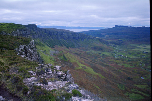
Along the top of Beinn Bhuidhe, south of Dunan Thalasgair
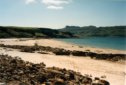
Singing Sands Beach
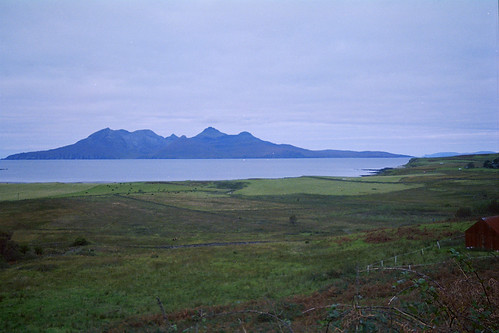
Rum, seen across Laig
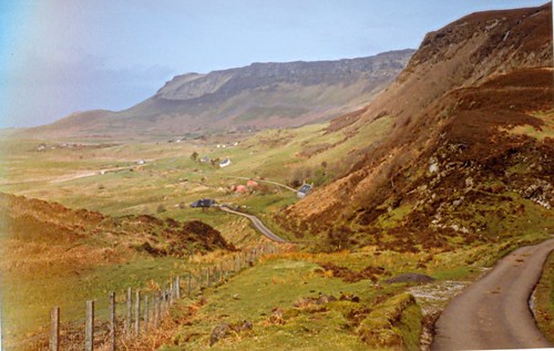
Cleadale
Thank you for all the lovely pictures. I did enjoy them so much and especially the beach of course. You do and have had some wonderful journeys
ReplyDelete