A day of very mixed fortunes. After an abysmal start to the day, with heavy rain, it brightened up - only for the wind to ratchet up a notch to force 7, with gusts to 45 mph. As I type this, the sun is going down and the wind is still blowing. We'll keep the wind well into tomorrow.
Yesterday, a
canoe overturned in the sea a few miles west of Gairloch, on the mainland. In it were two families, out for the day from Invergordon, north of Inverness. One of the adults went missing and three young children, aged 2, 5 and 5, have drowned. Another child and another adult managed to gain the shore to raise the alarm. The incident was the first headline on national news; initially only two youngsters had died, but it was announced at 7pm tonight that a third one had succumbed to the ordeal. The Coastguard have spent the day scouring Loch Gairloch for the missing man, but the search was changed to a recovery operation which was stood down when the weather deteriorated during the afternoon. Gairloch is about 45 miles southwest of Stornoway and has much the same weather patterns. Loch Gairloch is connected to the open waters of the Minch, and is known to have strong tidal currents, particularly on account of the island in the bay.
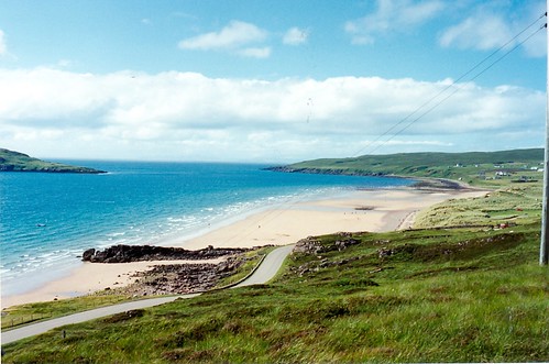 I took the above image on 26 July 1994. It shows the area where this tragedy played out yesterday
.
The northeastern coast of the Gulf of Mexico, from Louisiana eastward, are bracing themselves from a strike by tropical storm Isaac, which is forecast to intensify to hurricane force soon. The National Hurricane Center in Miami is predicting a storm surge of 6 to 12 feet along the Louisiana coastline, at precisely the location and date where Hurricane Katrina impacted in 2005. Isaac is expected to be "only" category I; Katrina was a cat III, downgraded from V, when it hit New Orleans.
