Libya's ousted dictator, Muammar Gaddafi, has indicated to the rebels that he wants to talk about forming a new government. I don't think he's quite grasping the state of affairs in his country. He is out, and will never be able to come back in any capacity. This evening's film footage of charred corpses at various locations across Tripoli would be enough reason in itself. Not to mention the 50,000 prisoners that are unaccounted for. These were people that were arrested following the start of the uprising on 17 February this year.
The transitional government of Libya (TNC), which has now taken over from Gaddafi, has refused point-blank to even consider extraditing Abdelbaset al-Megrahi. He is the sole man ever convicted over the bombing of PanAm flight 103 over Lockerbie on 21 December 1988. Al-Megrahi was jailed in Scotland, but released on compassionate grounds two years ago. He was suffering from terminal cancer, and given only three months to live. To the embarrassment of the Scottish Government, Al-Megrahi is still alive - although looking very gaunt. This weekend, the TNC announced that it would never extradite the Lockerbie bomber to either the UK or USA. And why should they? Al-Megrahi has been tried, found guilty and sentenced. He has been released on license, sent home to die. By law, you cannot be tried twice for the same offence, unless new evidence comes to light. The Americans agreed to have Al-Megrahi put to trial the way he was, a decade ago. So I agree with the TNC that Al-Megrahi can stay in Libya. To die.
Sunday, 28 August 2011
Sunday 28 August
A cold, grey and initially wet day. We did not get above 11C / 52F all day, with a cold and strong northwesterly wind blowing. The ferry sailed to Ullapool this afternoon, but is not coming back tonight, meaning that the 7 am sailing from Stornoway is off as well.
Tropical cyclone Irene passed over Times Square in New York at 9 am (local time) this morning, turning the barometer down to 966 mbar. It was below hurricane strength, although it was still packing some nasty winds on its eastern flank. Storm surge flooding did occur in the centre of the city, but all in all, Irene's impact appears to have been not as severe as initially feared. As I type (just after midday EDT), the circulation around the cyclone shows up quite nicely on the windmapper site. The highest winds, on Mount Washington, are "only" 53 mph - that's still a force 10 in my book. Elsewhere, the storm appears to be spinning down at severe gale force. Irene will be turning into an extra-tropical depression as it scoots away northeast over Labrador and out towards Greenland and Iceland.

Tropical cyclone Irene passed over Times Square in New York at 9 am (local time) this morning, turning the barometer down to 966 mbar. It was below hurricane strength, although it was still packing some nasty winds on its eastern flank. Storm surge flooding did occur in the centre of the city, but all in all, Irene's impact appears to have been not as severe as initially feared. As I type (just after midday EDT), the circulation around the cyclone shows up quite nicely on the windmapper site. The highest winds, on Mount Washington, are "only" 53 mph - that's still a force 10 in my book. Elsewhere, the storm appears to be spinning down at severe gale force. Irene will be turning into an extra-tropical depression as it scoots away northeast over Labrador and out towards Greenland and Iceland.

Saturday 27 August
A fairly bright day, but the wind rose steadily through the day. Sitting outside was therefore no longer an option. We are on warning for high winds tomorrow, but the worst of it appears to be making for the mainland and the Northern Isles.
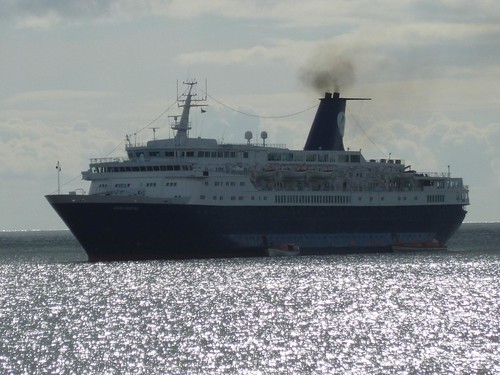
We once more have a cruiseliner in port, the Ocean Countess. Her passengers flock ashore, but wise to the extortionate coachtours they head for the service bus. However, local people and other tourists also want to go to Callanish, so it's handbags at lunchtime for a place on W2.
I'm monitoring the progression of Hurricane Irene up the East Coast of the US, and the main problem appears to be rain. The NHC is forecasting up to 20 inches, which is not an amount anyone wants to have within 24 hours. Another two tropical systems: typhoon Nanmadol is battering the north of the Philippines, and tropical storm Talas is creeping north - with Japan in its crosshairs.
Subscribe to:
Posts (Atom)