
Saturday, 17 October 2009
Hurricane update - 17 October
Hurricane Rick, which formed south of Acapulco on Thursday, is now a category IV hurricane as it moves west northwest, parallel to the south coast of Mexico. Sustained winds near its centre are at 125 knots, that's 140 mph (220 kph), and will exceed 140 knots by tomorrow. That makes it a category V hurricane. As the storm veers north, the seawater temperatures (currently near 30C) will fall, and the atmospheric conditions will no longer be conducive to sustaining this intensity. By the time Rick makes landfall in Baja California, expected on Wednesday or Thursday of next week, it will be a category II hurricane. Still enough to cause extensive damage and disruption. Website Baja Insider is giving the local view, albeit somewhat behind.


From the archives: Friday 15 October 2004

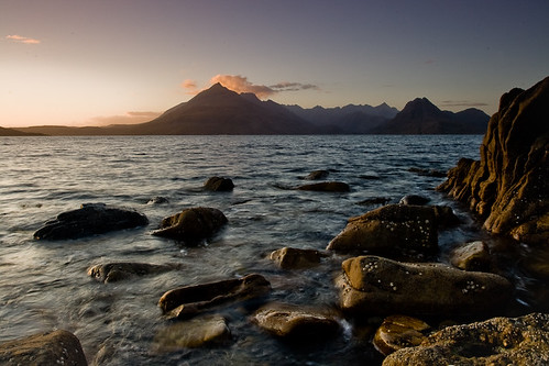
Saturday 17 October
No complaints about the weather, although the wind is a tad nippy. Mercury dipped to freezing overnight, but is currently nicely back up into double figures.
It is low tide at the moment, and it is quite a low tide, bearing in mind it is springtide. For those not much versed into matters tidal, when you get a springtide the flood tide comes in very high and the ebb tide very low. A few years ago, during an especially low tide, I was able to go out onto the exposed seabed and collect about 8 clams. No surprise then when I say that I never found another clam in the area concerned! It is quite disconcerting to think though that 6 hours later there was 17 feet of water above the place where I had been picking those shells.
Our MP has asked for the summer timetable for the ferries to be extended into November. Its current validity runs out next Saturday, October 24th. He states that the slashing of ferry fares, due to a government subsidy scheme, has promoted ferry traffic last summer. Mr Macneil appears to be unaware though that the tourist season tends to end at the close of the midterm break, i.e. by the penultimate weekend in October. Five years ago, when I was travelling western Scotland, I could not help but notice that everything ground to a stop by October 24th or thereabouts, and that was not related to the ferry services. Being in the Isle of Skye at the time, which can be reached by bridge, it was very noticeable. Also, the Stornoway to Ullapool ferry service is the same right through the year. Other services in the Western Isles do see a reduction in service though.
It is low tide at the moment, and it is quite a low tide, bearing in mind it is springtide. For those not much versed into matters tidal, when you get a springtide the flood tide comes in very high and the ebb tide very low. A few years ago, during an especially low tide, I was able to go out onto the exposed seabed and collect about 8 clams. No surprise then when I say that I never found another clam in the area concerned! It is quite disconcerting to think though that 6 hours later there was 17 feet of water above the place where I had been picking those shells.
Our MP has asked for the summer timetable for the ferries to be extended into November. Its current validity runs out next Saturday, October 24th. He states that the slashing of ferry fares, due to a government subsidy scheme, has promoted ferry traffic last summer. Mr Macneil appears to be unaware though that the tourist season tends to end at the close of the midterm break, i.e. by the penultimate weekend in October. Five years ago, when I was travelling western Scotland, I could not help but notice that everything ground to a stop by October 24th or thereabouts, and that was not related to the ferry services. Being in the Isle of Skye at the time, which can be reached by bridge, it was very noticeable. Also, the Stornoway to Ullapool ferry service is the same right through the year. Other services in the Western Isles do see a reduction in service though.
Friday, 16 October 2009
Friday 16 October
A beautiful sunny morning in Stornoway, with hardly a breath of wind. Quite cool, at present only 8C / 46F. Overnight low was +2C / 36F.
Far-right Dutch politician Geert Wilders is returning to the UK after overturning a ban on his entry to the UK, previously imposed by the UK Home Office. Mr Wilders produced an anti-Islam movie, Fitna, in March last year, which raised a furore but was in my mind too stupid to waste 15 minutes of my time on. Geert Wilders is the leader of a political party in Holland, which is as intolerant as the country's reputation is tolerant. I do not understand why he is so revered over there - I think he's a proper disgrace.
Late last night, two hillwalkers were taken to safety from the Steall gorge near Fort William, after becoming disoriented in the dark. I know the area myself, and it is quite tricky to negotiate in daytime. If you're on the south bank of the river, you have to cross it using a single wire.

Water of Nevis at Steall

Wire bridge at Steall
Pictures courtesy Flickr-user HighlandSC
Far-right Dutch politician Geert Wilders is returning to the UK after overturning a ban on his entry to the UK, previously imposed by the UK Home Office. Mr Wilders produced an anti-Islam movie, Fitna, in March last year, which raised a furore but was in my mind too stupid to waste 15 minutes of my time on. Geert Wilders is the leader of a political party in Holland, which is as intolerant as the country's reputation is tolerant. I do not understand why he is so revered over there - I think he's a proper disgrace.
Late last night, two hillwalkers were taken to safety from the Steall gorge near Fort William, after becoming disoriented in the dark. I know the area myself, and it is quite tricky to negotiate in daytime. If you're on the south bank of the river, you have to cross it using a single wire.
Water of Nevis at Steall
Wire bridge at Steall
Pictures courtesy Flickr-user HighlandSC
Thursday, 15 October 2009
From the archives: Tuesday 12 October 2004

Well, all good things must come to an end. On Tuesday morning, I moodily packed up my things. Unfortunately, when I came down to Kildonan, my backpack was transported to the house for me. So its weight came as an unpleasant surprise. Said goodbye to my hosts and lumbered across to the pier in 60 minutes. That is actually normal time, especially bearing in mind I diverted through the Lodge Gardens. On arrival at the pier, the Eiggach were in great confusion regarding The Boat. It was very well known that the regular one, Lochnevis, was away for its refit. The Raasay, a very much smaller craft, was taking its place for cargo. At midday, a mast appeared above the pier and everybody streamed down to have a look. No passengers. At 1pm, another cry "the boat is here" sent me scurrying down the pier again. This time round, it was for passengers. I could see nothing of it until I got to the point where John Cormack was standing. "Erm, John?" I went. "Did they wash Lochnevis at too high a temperature?" The Ullin Staffa was really wee. But a lot faster than Lochnevis. It covered the distance to Mallaig in 60 minutes, where the regular ferry takes 80 minutes. On departure from the pier at 1.15, the sea was choppy, and we took over a fair amount of seaspray. Some of the kids turned green and were sent out on deck for some fresh air. One young girl was beyond help and proceeded to spew up over the side. Nice. The adults stuck to their devices for keeping seasickness at bay. Arrival in Mallaig at 2.15, and we had to clamber onto the loading ramp for Coruisk, the Skye ferry. This materialized at 2.40. Coruisk was taken into service on 14/8/03, only to be taken out again before the month was out because she had lost a propellor on entering Mallaig Harbour. I had to wait for a bus for 2 hours at Armadale. I walked down the road to Aird for a bit, sat on a grassy knoll and had a coke in the local pub. On return at the main road, I stood waiting for the 5.35 from Armadale Pier, when one of the shopkeepers advised me that "this was not a stop". No. But the bus would stop there anyhow. However, I didn't want a row, so I dutifully toddled off to the Pier and boarded the number 52 for Broadford at 5.35.
From the archives: Monday 11 October 2004
Went out earlier than before, and tootled across to the Pier to start with. From Kildonan Farm House, you can actually short cut to the Pier via the cliffs. Of course, you must cross some fences :-\, but they're there to keep the sheep in. I finally reached the point opposite the pier, and came across Lady Runciman's Bathing Hut. No longer up to spec, as several planks were missing from the walls, and Lady R would have been severely embarrassed changing in there. Whether she actually did go for a dip in the days of yore, history does not recall. My attempts to cross Pier Bay were thwarted by deep and wide streams. And the sea of course. I had to wind my way around the obstacles and found myself outside Shore Cottage. No problem, I just walked round to An Laimhrig. There I partook of a cup of Nescafe, 50p, and chatted to a yachtswoman who was over with her family out of Ayrshire. Later that day she would sail, with hubby, young boy and dog, to Soay, 15 miles away under the Skye Cuillins. Apparently 2 people live there, but the Arisaig boat Sheerwater delivers their mail. Why the Western Isles (Mallaig based) or even the Bella Jane (Elgol, right opposite Soay) cannot do that, nobody knows. Later on that day, the golden labrador would bite Diesel, the Carr's dog, for mischievous behaviour. The lab behaved impeccably. Diesel, a lil monster, did not. I marched up Pier Hill, past Galmisdale and up the path to the Scurr. That is well eroded and little better than a mudchute. I did comment on that to some people, but did not receive much of an active reply. Once underneath the Scurr ridge, I diverted to Lochan nam Ban Mora (Loch of the Big Women) to find the bench, which had been placed there earlier in the year in memory of Brigg Lancaster.
 He had died early in 2003 in a road traffic accident on the island, when his jeep left the road at Sandavore, and it rolled over. As this happened at 2am, he was not found for another 8 hours. Although he was still alive when he was found, he succumbed to his injuries. Brigg, aged 31, left a wife and a one-year old girl. The plaque on the bench simply reads 'honesty'. A bottle of whisky is commonly left at the bench, for people to have a dram. Unfortunately, the Famous Grouse had been smashed. I just sat there in complete silence, looking over the water of the lochan. Later on, I went on my way. I met Brigg only once, before he got married to Tasha Fyffe. He seemed a decent enough person.
Although I have visited Eigg for 15 years, I still managed to get lost amongst the lochans. I had to get the map out (disgrace) to remind myself of their location.

Next stop: Lochan Nighean Dougaill, Lochan of Dougal's Daughter. Her lungs were alleged found floating on the surface of the lochan after she was abducted from the nearby township of Grulin. The abductor was a kelpie, one of the good people, of whom we cannot speak. Grulin was cleared in the 1850s, and now only ruins and the bothy remain. With some difficulty, I managed to wind my way around to the Twin Lochs, at an altitude close to 1,000 feet. Corra-bheinn towered some distance to the northeast, above its own lochan, which I could not see. I had to stay that high because of Glen Charadail, which cuts deeply into the hills here.

The Twin Lochs can be crossed at midpoint, but be prepared for wet feet. The traverse to the western end of Lochan Beinn Tighe is a nightmare, 2ft high tussocks of heather and boulders. I disturbed 3 sheep, missed by the shepherd George Carr, so he has a job to go and retrieve them lol. Clambering over more boulders round the shoulders of Beinn Tighe, I finally managed to reach reasonable terrain at 3.15. I collapsed on the shores of the lochan and took a 45 minute break. Then followed a fairly speedy descent towards Laig, but not without the infernal barbed-wire fencing. And when you ignore clear warnings in the terrain that you're standing above a cliff, well, you have to clamber. Don't you. LOL. Reached Laig at 17.30, and the main road at 18.05. Although it's only a mile, there were plenty of blackberries to distract me. I came across Liz Lyons and Morag MacKinnon, outside's the former's pigsty - sorry, yard. Morag's cows were blocking the road further on at the summit of Bealach Clithe, so that was an interesting exercise in shooing the damn creatures to the side. Arrived back at Kildonan at 18.55. A good, long day, and I was well knackered. Asked for a rum coke - for those who don't know me, I hardly ever touch liquor.

 He had died early in 2003 in a road traffic accident on the island, when his jeep left the road at Sandavore, and it rolled over. As this happened at 2am, he was not found for another 8 hours. Although he was still alive when he was found, he succumbed to his injuries. Brigg, aged 31, left a wife and a one-year old girl. The plaque on the bench simply reads 'honesty'. A bottle of whisky is commonly left at the bench, for people to have a dram. Unfortunately, the Famous Grouse had been smashed. I just sat there in complete silence, looking over the water of the lochan. Later on, I went on my way. I met Brigg only once, before he got married to Tasha Fyffe. He seemed a decent enough person.
Although I have visited Eigg for 15 years, I still managed to get lost amongst the lochans. I had to get the map out (disgrace) to remind myself of their location.
Hurricane update - 15 October
The Atlantic hurricane season remains as lifeless as the proverbial dodo, but the East Pacific season, which runs concurrently with the Atlantic one, is roaring. This evening, storm number 20 formed, some 400 miles south of Acapulco and what will be Rick is expected to strengthen very quickly indeed, to hurricane force as early as Saturday (GMT) and major hurricane by late Sunday. Although the storm is currently heading away from land, it is expected to veer northwest, and could be on a collision course with Baja Califormia - with winds of at least 115 knots - early next week.
The West Pacific typhoon season is also in conveyor belt mode. After tropical storm Parma finally disappeared from the weather charts after gracing them with its presence for 17 days, we now have tropical storm Lupit east of the Philippines. By the time this storm reaches Luzon Island, it could be a category IV typhoon. As if Luzon hasn't already had enough typhoons this season: after 3 helpings of Parma, preceeded by a deadly deluge from Ketsana, Lupit could deliver another heavy blow with 125 knot winds and the usual catastrophic downpours.
It is habitual to retire hurricane / typhoon names if a storm, carrying that name, has caused catastrophic loss of life and / or damage to property. There will never be a hurricane Katrina, or a typhoon Durian. Ketsana is also unlikely to reappear again in 6 years' time (the lists of names rotate on a 6 year cycle). Last year, no Western Pacific typhoon names were retired. There will be quite a handful this year, unless I'm badly mistaken.
The West Pacific typhoon season is also in conveyor belt mode. After tropical storm Parma finally disappeared from the weather charts after gracing them with its presence for 17 days, we now have tropical storm Lupit east of the Philippines. By the time this storm reaches Luzon Island, it could be a category IV typhoon. As if Luzon hasn't already had enough typhoons this season: after 3 helpings of Parma, preceeded by a deadly deluge from Ketsana, Lupit could deliver another heavy blow with 125 knot winds and the usual catastrophic downpours.
It is habitual to retire hurricane / typhoon names if a storm, carrying that name, has caused catastrophic loss of life and / or damage to property. There will never be a hurricane Katrina, or a typhoon Durian. Ketsana is also unlikely to reappear again in 6 years' time (the lists of names rotate on a 6 year cycle). Last year, no Western Pacific typhoon names were retired. There will be quite a handful this year, unless I'm badly mistaken.
Thursday 15 October
Overcast with occasional drizzle today, but not cold at 13C this morning. Roadworks in my area of Stornoway sends cars onto the pavement, without a thought for the pedestrians on said pavement. Wonderful.
Two weeks ago, three people died when their car was struck by a train on a level crossing at Halkirk, in the far north of mainland Scotland. The cause of the accident is being investigated, and my comments below are not a reflection on any party involved in that tragic collision. The traindrivers' union ASLEF has said its members will slow down to 20 mph at any level crossing without barriers (the one at Halkirk only had lights). There has already been a negative reaction to that plan, if only because the Inverness to Thurso train already takes 4 hours to cover the 150 miles, and this go-slow would extend journeytimes even further. It would disadvantage the train against the bus, which incidentally, also takes 4 hours.
In my opinion, car drivers should be compelled to come to a full stop at any railway level crossing without barriers, then proceed slowly across. I believe that the current Highway Code already states that the onus is on the driver to ensure the crossing is safe to tackle, as the train cannot stop. After the train struck the car at Halkirk, it took a quarter of a mile to come to a full stop, although it was only doing the statutory 50 mph. Also, there is a litany of incidents of crazy drivers who fly across level crossings when the lights are flashing, barriers coming down (or already fully down). It is not the trains that should slow down - it's the drivers that should.
Two weeks ago, three people died when their car was struck by a train on a level crossing at Halkirk, in the far north of mainland Scotland. The cause of the accident is being investigated, and my comments below are not a reflection on any party involved in that tragic collision. The traindrivers' union ASLEF has said its members will slow down to 20 mph at any level crossing without barriers (the one at Halkirk only had lights). There has already been a negative reaction to that plan, if only because the Inverness to Thurso train already takes 4 hours to cover the 150 miles, and this go-slow would extend journeytimes even further. It would disadvantage the train against the bus, which incidentally, also takes 4 hours.
In my opinion, car drivers should be compelled to come to a full stop at any railway level crossing without barriers, then proceed slowly across. I believe that the current Highway Code already states that the onus is on the driver to ensure the crossing is safe to tackle, as the train cannot stop. After the train struck the car at Halkirk, it took a quarter of a mile to come to a full stop, although it was only doing the statutory 50 mph. Also, there is a litany of incidents of crazy drivers who fly across level crossings when the lights are flashing, barriers coming down (or already fully down). It is not the trains that should slow down - it's the drivers that should.
Wednesday, 14 October 2009
Wednesday 14 October
Overcast once more, but dry. There is a breeze, but nothing too disconcerting. A contact in San Francisco is telling me stories about the big storm, the remnant of typhoon Melor, which has hit the area. Deep snow has fallen in the Sierra Nevada, and warnings abound about flooding. Tropical storm Parma is coming ashore in Vietnam, and will dissipate later today, after 17 days on the go. That is a respectable lifespan for a tropical system - the record stands at 30 days. A new cyclone has formed east of Guam, which will now see a third tropical storm whizz by. In the 3 years of hurricane watching, I've not seen this many storms pass over the Northern Marianas. 22W, the current name for the new system, will head for the Philippines, which is having a singularly bad year. It got three helpings of Parma - I think I'd prefer the ham they make in Parma.
The body of a man, clad in a wetsuit, has washed ashore on the beach at Camas Fionary in Skye, pictured below (the top marker on the map). His apparel suggests that this was the diver who went missing off Ardnamurchan Point (bottom marker) 12 days ago. The outcome of a post-mortem examination is awaited before police will confirm or deny that this is the case.

The body of a man, clad in a wetsuit, has washed ashore on the beach at Camas Fionary in Skye, pictured below (the top marker on the map). His apparel suggests that this was the diver who went missing off Ardnamurchan Point (bottom marker) 12 days ago. The outcome of a post-mortem examination is awaited before police will confirm or deny that this is the case.
Tuesday, 13 October 2009
From the archives: Sunday 10 October 2004
From October 9 to 12, 2004, I stayed in the Isle of Eigg. I have a long-standing acquaintance with that small island, which goes back to 1989. My abiding memory of that first visit was a stunningly beautiful island, littered with wrecked and cannibalised cars, generators throbbing in the night, and conking out just as you're having your supper (leaving you in the dark).
Sunday 10th October dawned overcast but clear. The visibility was going to be the dominant feature. After breakfast, I left Kildonan at about 10.30, I really should not be keeping my host from her work by yakking so much lol. My progress up Eigg's main road keeps being impeded by ripe blackberries. Which obviously, I have to go and pick. Anyway, the piece de resistance of the road north through the island comes when you descend Bealach Clithe [pronounced Byalach Cleey] and first the towering mountains on the neighbouring island of Rum (seriously, the place is called that) hove into view. At 2,800 feet, they are impressive at 4.5 miles distance. The next corner reveals the green swathe of Cleadale, the crofting community, over which the 1,000 foot high cliffs of Beinn Bhuidhe [Ben Vooy] tower to the east. I slowly ambled down the road, past the houses of Cuagach, the terrible sideroad to Laig Farm and the old folks houses. Then you arrive at a T-junction, at which I went left, towards Seaview. This house was occupied by Angus MacKinnon, one of the island's elders until his death, a few years ago. It appears to be empty now. The blackberries distracted me. You can walk to Camus Sgiotaig, the Beach of Singing Sands from Seaview, but don't fall off the cliffs. You've got a bit of a job finding the way down. Don't chase the sheep over the cliffs either. Please. Once on the beach, the white sands, if dry, produce a shrill shriek if you rub your shoes over it. Or just walk over it. The streams cut a deep channel right through the sands, and you've got to be careful not to fall through the layer of sands if the water has undercut it. Otters have been seen playing in the kelp on the tideline. Towards the south, there are caves and natural arches to explore. It should be possible to walk back to Laig Beach, a mile to the south, but do watch the tides. I climbed up the hill at the north end of Camus Sgiotaig and ploughed through some dead bracken towards the pass of Bealach Thuilm. If you want to you can cross the stile and descend into Talm, which is overlooked by an 1,100 foot high cliff, Dunan Thalasgair. I climbed up the green hill behind the Dunan right to the top of the cliffs. Took me 15 minutes, but left me well out of breath. On the top, I got a signal on the mobile. Transmitter is located at Mallaig, 10 miles distant to the northeast. I went through the gate and proceeded to walk south. The views were phenomenal. I could see the Outer Hebrides from Barra Head north to South Uist, then again North Uist to Berneray and possibly Harris. To the south, I saw Tiree, the Treshnish Isles and Staffa and Mull. Having gorged myself on this panorama, I went south. Right by the edge of this cliff, only inches away from it. Not for those suffering from vertigo. Met a lady with her children, who had climbed up to the ridge from a point a few miles south. Then it's a case of following the cliff edge south, and choosing a route. Those heading for Kildonan just take aim for the farmhouse and make your way across. Beware of barbed wire fencing, and beware not to underestimate the distance.

Along the top of Beinn Bhuidhe, south of Dunan Thalasgair

Singing Sands Beach

Rum, seen across Laig

Cleadale
Sunday 10th October dawned overcast but clear. The visibility was going to be the dominant feature. After breakfast, I left Kildonan at about 10.30, I really should not be keeping my host from her work by yakking so much lol. My progress up Eigg's main road keeps being impeded by ripe blackberries. Which obviously, I have to go and pick. Anyway, the piece de resistance of the road north through the island comes when you descend Bealach Clithe [pronounced Byalach Cleey] and first the towering mountains on the neighbouring island of Rum (seriously, the place is called that) hove into view. At 2,800 feet, they are impressive at 4.5 miles distance. The next corner reveals the green swathe of Cleadale, the crofting community, over which the 1,000 foot high cliffs of Beinn Bhuidhe [Ben Vooy] tower to the east. I slowly ambled down the road, past the houses of Cuagach, the terrible sideroad to Laig Farm and the old folks houses. Then you arrive at a T-junction, at which I went left, towards Seaview. This house was occupied by Angus MacKinnon, one of the island's elders until his death, a few years ago. It appears to be empty now. The blackberries distracted me. You can walk to Camus Sgiotaig, the Beach of Singing Sands from Seaview, but don't fall off the cliffs. You've got a bit of a job finding the way down. Don't chase the sheep over the cliffs either. Please. Once on the beach, the white sands, if dry, produce a shrill shriek if you rub your shoes over it. Or just walk over it. The streams cut a deep channel right through the sands, and you've got to be careful not to fall through the layer of sands if the water has undercut it. Otters have been seen playing in the kelp on the tideline. Towards the south, there are caves and natural arches to explore. It should be possible to walk back to Laig Beach, a mile to the south, but do watch the tides. I climbed up the hill at the north end of Camus Sgiotaig and ploughed through some dead bracken towards the pass of Bealach Thuilm. If you want to you can cross the stile and descend into Talm, which is overlooked by an 1,100 foot high cliff, Dunan Thalasgair. I climbed up the green hill behind the Dunan right to the top of the cliffs. Took me 15 minutes, but left me well out of breath. On the top, I got a signal on the mobile. Transmitter is located at Mallaig, 10 miles distant to the northeast. I went through the gate and proceeded to walk south. The views were phenomenal. I could see the Outer Hebrides from Barra Head north to South Uist, then again North Uist to Berneray and possibly Harris. To the south, I saw Tiree, the Treshnish Isles and Staffa and Mull. Having gorged myself on this panorama, I went south. Right by the edge of this cliff, only inches away from it. Not for those suffering from vertigo. Met a lady with her children, who had climbed up to the ridge from a point a few miles south. Then it's a case of following the cliff edge south, and choosing a route. Those heading for Kildonan just take aim for the farmhouse and make your way across. Beware of barbed wire fencing, and beware not to underestimate the distance.
Along the top of Beinn Bhuidhe, south of Dunan Thalasgair
Singing Sands Beach
Rum, seen across Laig
Cleadale
Referendum
I'm not that much of a political animal, although I can get a bit hot under the collar over local issues. Windfarms is one of them. But that's not what this post will be about. It will be on quite a contentious issue: Scottish independence.
At the moment, the devolved government in Edinburgh is run by the Scottish National Party, headed by its leader Alex Salmond. The stated aim and objective of the SNP is to gain full independence for Scotland, and to leave the United Kingdom. During the elections for the Scottish Parliament in 2007, the SNP promised it would organise a referendum on independence within its first term in office. The party scraped into office by the margin of 1 seat, leaving it in a minority government. It needs the cooperation of other political parties to get any major legislation passed. The other main parties at Holyrood (the seat of the Scottish Parliament) are opposed to full independence for Scotland.
As matters stand, the SNP will not be able to organise a referendum, as they do not hold the necessary mandate in parliament. It is therefore necessary for them to persuade other parties to agree to a referendum. And that's where it gets interesting. Independence comes in shapes and sizes, it is not as black and white as it may appear to be on first sight. The Scottish Government could be granted powers to levy its own income tax, in other words, that more powers be devolved to it from the UK Government in London. Full independence would mean that Scotland would organise its own defence, and have its own foreign policy. And there are all sorts of shades of grey in between.
Which brings the focus on the referendum, and the questions to be asked therein. If the SNP wants to get its referendum off the ground, it would appear likely that concessions need to be made at this stage - in terms of how far any increase in devolved powers would go as a result of said referendum. It is, however, not a wholly Scottish affair. It is a United Kingdom matter. Will this referendum, and its outcome, lead to the break-up of the Union?
My perception of this situation is that it could, potentially, lead to the break-up of the UK. The way politicking is going at the moment in Scotland, I cannot see a referendum coming off the ground. If anything, bearing in mind the SNP's stated objective (the break-up of the United Kingdom), I would be opposed to having it.
At the moment, the devolved government in Edinburgh is run by the Scottish National Party, headed by its leader Alex Salmond. The stated aim and objective of the SNP is to gain full independence for Scotland, and to leave the United Kingdom. During the elections for the Scottish Parliament in 2007, the SNP promised it would organise a referendum on independence within its first term in office. The party scraped into office by the margin of 1 seat, leaving it in a minority government. It needs the cooperation of other political parties to get any major legislation passed. The other main parties at Holyrood (the seat of the Scottish Parliament) are opposed to full independence for Scotland.
As matters stand, the SNP will not be able to organise a referendum, as they do not hold the necessary mandate in parliament. It is therefore necessary for them to persuade other parties to agree to a referendum. And that's where it gets interesting. Independence comes in shapes and sizes, it is not as black and white as it may appear to be on first sight. The Scottish Government could be granted powers to levy its own income tax, in other words, that more powers be devolved to it from the UK Government in London. Full independence would mean that Scotland would organise its own defence, and have its own foreign policy. And there are all sorts of shades of grey in between.
Which brings the focus on the referendum, and the questions to be asked therein. If the SNP wants to get its referendum off the ground, it would appear likely that concessions need to be made at this stage - in terms of how far any increase in devolved powers would go as a result of said referendum. It is, however, not a wholly Scottish affair. It is a United Kingdom matter. Will this referendum, and its outcome, lead to the break-up of the Union?
My perception of this situation is that it could, potentially, lead to the break-up of the UK. The way politicking is going at the moment in Scotland, I cannot see a referendum coming off the ground. If anything, bearing in mind the SNP's stated objective (the break-up of the United Kingdom), I would be opposed to having it.
Tuesday 13 October
Overcast and windy this morning, but as yet dry. The rainfall radar suggests the odd spot of rain is possible.
I am sad to report the death of my aunt at the age of 70. She was the youngest sister of my mother who passed away nearly 18 months ago.
Inverness could lose a landmark building to the wrecking ball, if councillors vote to demolish Viewhill House, the city's former youth hostel. I remember staying there in 1996, before the new hostel was built on the eastern outskirts of the city centre. Viewhill House was built 170 years ago by an engineer who constructed the Caledonian Canal alongside Thomas Telford. The below picture, from July 1996, shows the view from the building.

I am sad to report the death of my aunt at the age of 70. She was the youngest sister of my mother who passed away nearly 18 months ago.
Inverness could lose a landmark building to the wrecking ball, if councillors vote to demolish Viewhill House, the city's former youth hostel. I remember staying there in 1996, before the new hostel was built on the eastern outskirts of the city centre. Viewhill House was built 170 years ago by an engineer who constructed the Caledonian Canal alongside Thomas Telford. The below picture, from July 1996, shows the view from the building.
Monday, 12 October 2009
Monday 12 October
Overcast today, but dry. Rain covers the Scottish mainland north and northwest of Inverness, but whatever rain we had has now moved away east. The moutains on the mainland, 50 miles to the east, stand out fairly clearly this afternoon. It does not feel very warm at all, with the mercury only just above 10C today.
Locally, it appears to be a thin news day, which is not unusual. Just been into town myself for a few bits and pieces, including (on request) a book on Norse Mills in this island. Late in August, I went on a guided tour with a dozen other folks to half a dozen sites where mills used to be situated. It was an interesting trip, not just because of the subject matter, but also because the weather was plain awful - wet and cold.

Norse Mill and Kiln at Shawbost, 29 August 2009
Locally, it appears to be a thin news day, which is not unusual. Just been into town myself for a few bits and pieces, including (on request) a book on Norse Mills in this island. Late in August, I went on a guided tour with a dozen other folks to half a dozen sites where mills used to be situated. It was an interesting trip, not just because of the subject matter, but also because the weather was plain awful - wet and cold.
Norse Mill and Kiln at Shawbost, 29 August 2009
Sunday, 11 October 2009
Evening notes
The land-based search for 83-year old Clifford Wannop, missing whilst on holiday in the Isle of Skye, has been stood down. Police will conduct inquiries as for his use of public transport in Skye or appearance in nearby villages. Mr Wannop hails from the Channel Islands and is described as very fit for his age.
Tomorrow, the Royal National Mod 2009 will swing into full gear. This annual celebration of Gaelic culture takes place in Oban, on the west coast of mainland Scotland, some 90 miles northwest of Glasgow. The focus is on music, although acting and sports also have a part to play. Four years ago, the Mod was in Stornoway and I recorded several dozen performances - you can have a listen via my Mod page.
I am pleased to note that Coastguard tug Anglian Prince is back in operation after it broke down near Ullapool last week. AIS Minch shows it in Loch Ewe this evening, awaiting a call out for its services. A tug was put on stand-by in the Minch some years ago, as it is used as a shortcut by ships carrying dangerous cargoes like crude oil. If anything goes wrong, the tug can be there within a short space of time, rather than having to come all the way from Oban or even further afield.

Anglian Prince at Stornoway on 18 April 2007
Tomorrow, the Royal National Mod 2009 will swing into full gear. This annual celebration of Gaelic culture takes place in Oban, on the west coast of mainland Scotland, some 90 miles northwest of Glasgow. The focus is on music, although acting and sports also have a part to play. Four years ago, the Mod was in Stornoway and I recorded several dozen performances - you can have a listen via my Mod page.
I am pleased to note that Coastguard tug Anglian Prince is back in operation after it broke down near Ullapool last week. AIS Minch shows it in Loch Ewe this evening, awaiting a call out for its services. A tug was put on stand-by in the Minch some years ago, as it is used as a shortcut by ships carrying dangerous cargoes like crude oil. If anything goes wrong, the tug can be there within a short space of time, rather than having to come all the way from Oban or even further afield.
Anglian Prince at Stornoway on 18 April 2007
Sunday 11 October
Fairly bright in the Western Isles today, although there are some clouds and showers about. It is a typically quiet day (it being Sunday), and although we have now had a Sunday ferry for 3 months, I have not noticed any change to the Stornoway Sunday. The ferry leaves in a huge cloud of exhaust fumes (which nearly took my breath away yesterday) at 2.30pm and slips back into its birth some 6½ hours later quite unobtrusively. More so because it's dark at 9pm now.
More later.
More later.
Saturday, 10 October 2009
Front picture
I have once more changed the picture, heading this blog, to an image I took last Wednesday during a visit to Bosta Beach in Great Bernera. What is littering the beach is seaweed, torn loose in recent gales. The island in the distance is called Old Hill, which can be seen from near the Butt of Lewis, some 35 miles to the northeast.
70 years ago - this Tuesday
On 13 October 1939, the Royal Navy's HMS Royal Oak, at anchor in Scapa Flow, Orkney, was struck by four torpedoes from German submarine U-47. The first torpedo did no major damage when it struck just before 1 am. The last three torpedoes, fired at 1.16 am, proved fatal. Within 13 minutes, Royal Oak turned turtle and went to the bottom, taking 833 crew with her. She currently still lies in 100 feet of water, upside down, reaching 5 metres / 17 feet below the surface of the water. The site is marked by a green wreck buoy and has been marked as a wargrave.
Tomorrow, the 70th anniversary of this tragedy will be remembered in Orkney's main town, Kirkwall. Last year, I visited Orkney and called in at the Royal Oak memorial ashore at Scapa, near the local Coastguard Station. I'll share some of the pictures I took at the time, dedicating this entry to the memory of all those lost there in 1939.


The wreckbuoy
Tomorrow, the 70th anniversary of this tragedy will be remembered in Orkney's main town, Kirkwall. Last year, I visited Orkney and called in at the Royal Oak memorial ashore at Scapa, near the local Coastguard Station. I'll share some of the pictures I took at the time, dedicating this entry to the memory of all those lost there in 1939.
The wreckbuoy
Appeal to those across the pond
I relay an appeal by Dr Jeff Masters, who writes a blog on tropical cyclones (hurricanes etc.). He is warning that a satellite which provides crucial data on forecasting tropical cyclones, QuikSCAT, is about to fail. The satellite measures windspeeds and direction at the earth's surface, and has been in action for 10 years, well beyond its 2-3 year lifespan. If the funding cycle is initiated now, a replacement satellite could be in orbit by 2015. QuikSCAT's data save $135m a year in costs for shipping etc.
If you are in the USA and read this, please take the time to head over to Dr Masters' blog and get in touch with your local Senator to urge them to vote against a senate amendment, which would see a $172m cut in NOAA's budget to be diverted to law enforcement.
Please relay.
If you are in the USA and read this, please take the time to head over to Dr Masters' blog and get in touch with your local Senator to urge them to vote against a senate amendment, which would see a $172m cut in NOAA's budget to be diverted to law enforcement.
Please relay.
Saturday 10 October
Fairly bright in Stornoway this morning, with some drizzle on and off. Some light showers show on the rainfall radar out in the Atlantic. It looks as if our temperatures are on a slow downward slope (what do you expect in autumn).
A search is continuing on the Isle of Skye, south of here, for a man of 83 who has been missing since October 3rd. Clifford Wannop went for a walk in the Kinloch area of Skye, about 6 miles south of Broadford, and has not returned. Mr Wannop, pictured on this BBC link, is described as fit and active for his age, giving the impression of a man in his sixties rather than his eighties. Kinloch is a hilly, wooded area, bordering on the Sound of Sleat, which separates Skye from the Scottish mainland. There are several walking trails in the area, one leading to a deserted village (Leitir Fura), and one other going the 8 miles northeast to Kyle Rhea. Three regional mountain rescue teams will conduct a thorough search today, Saturday.
A northern bottle-nosed whale, which had become stuck in Loch Linnhe near Fort William, has died. A huge rescue effort had been mounted all week to try to coax the cetacean out to the open sea. At one stage, underwater recordings of the sounds of a killer whale were played to try to get the whale to move away. It did not manage to get past the Narrows of Corran, which would have allowed it to proceed to open waters.
A search is continuing on the Isle of Skye, south of here, for a man of 83 who has been missing since October 3rd. Clifford Wannop went for a walk in the Kinloch area of Skye, about 6 miles south of Broadford, and has not returned. Mr Wannop, pictured on this BBC link, is described as fit and active for his age, giving the impression of a man in his sixties rather than his eighties. Kinloch is a hilly, wooded area, bordering on the Sound of Sleat, which separates Skye from the Scottish mainland. There are several walking trails in the area, one leading to a deserted village (Leitir Fura), and one other going the 8 miles northeast to Kyle Rhea. Three regional mountain rescue teams will conduct a thorough search today, Saturday.
A northern bottle-nosed whale, which had become stuck in Loch Linnhe near Fort William, has died. A huge rescue effort had been mounted all week to try to coax the cetacean out to the open sea. At one stage, underwater recordings of the sounds of a killer whale were played to try to get the whale to move away. It did not manage to get past the Narrows of Corran, which would have allowed it to proceed to open waters.
Friday, 9 October 2009
From the archives: Saturday 9 October 2004
A perfect autumn day. Crisp, cool, practically windless. Skye looked perfect in the morning sun, as I took the bus down to Broadford, and then on to Armadale. I just could not get enough of the magnificent landscapes along the 27 miles to the ferry terminal. Coruisk came in on time at 11.40 and left 5 minutes later. It's been called all sorts of unfriendly names, like an 'inverted flowerpot'. On one of its first journeys, it lost a propellor on rocks in Mallaig harbour, in August 2003. But it chugged across the Sound of Sleat in 23 minutes, and offered the familiar view up to Isle Ornsay, Sandaig Islands to the north and Eigg and Rum to the southwest. After two hours of dawdling through Mallaig, Lochnevis entered the harbour and embarkation began. The couple that I met yesterday at Strathaird was on board, following my glowing endorsement of the 7 hour round trip. I talked them through the first 75 minutes to Eigg. On arrival, at 3.20, my host, Marie, was waiting on the pier, also to collect her daughter on half-term hols. The ferry waited 20 minutes, doing nothing, until formal departure time came. I sat in the jeep to be driven the 100-200 yards to An Laimhrig, the Anchorage. This is the teashop/craftshop/general store building at the end of the new pier. Check out the Isle of Eigg website www.isleofeigg.org for further details. Having bought a can of coke, I speedmarched off up Pier Hill towards the Lodge and Galmisdale. The low autumn sun lit everything up in a way I had never seen in the 15 years of coming to the island. It was, again, a perfect afternoon. I continued up the hill, to Galmisdale, with its glaringly red roof. Then further along to Grulin, where I went as far as the Bothy, 1 1/2 miles in. I sat in the sun, looking out over the water to the Isles of Muck, Coll, Mull and the Dutchman's Cap and Staffa. At 5.15, I decided to head back. Temperatures started to drop, and I was glad to reach Kildonan, where I was going to stay for the next few days.

Kyleakin

Lodge gardens, Isle of Eigg

Grulin, Isle of Eigg; An Sgurr in the centre
Kyleakin
Lodge gardens, Isle of Eigg
Grulin, Isle of Eigg; An Sgurr in the centre
Subscribe to:
Posts (Atom)